Noise Exposure Map Update
The Boca Raton Airport Authority (BRAA), along with Ricondo and Associates, has initiated a project to update the Boca Raton Airport Noise Exposure Map (NEM). This update will analyze the most recent annual aircraft operations and noise impacts to determine the levels of aviation related noise around the Airport, in accordance with federal guidelines. The last Federal Aviation Administration (FAA)-accepted Noise Exposure Map was completed in 2001 and updated noise contours were completed in 2017. This update aims to provide a current representation of noise exposure to assess land use compatibility in areas surrounding the Airport.
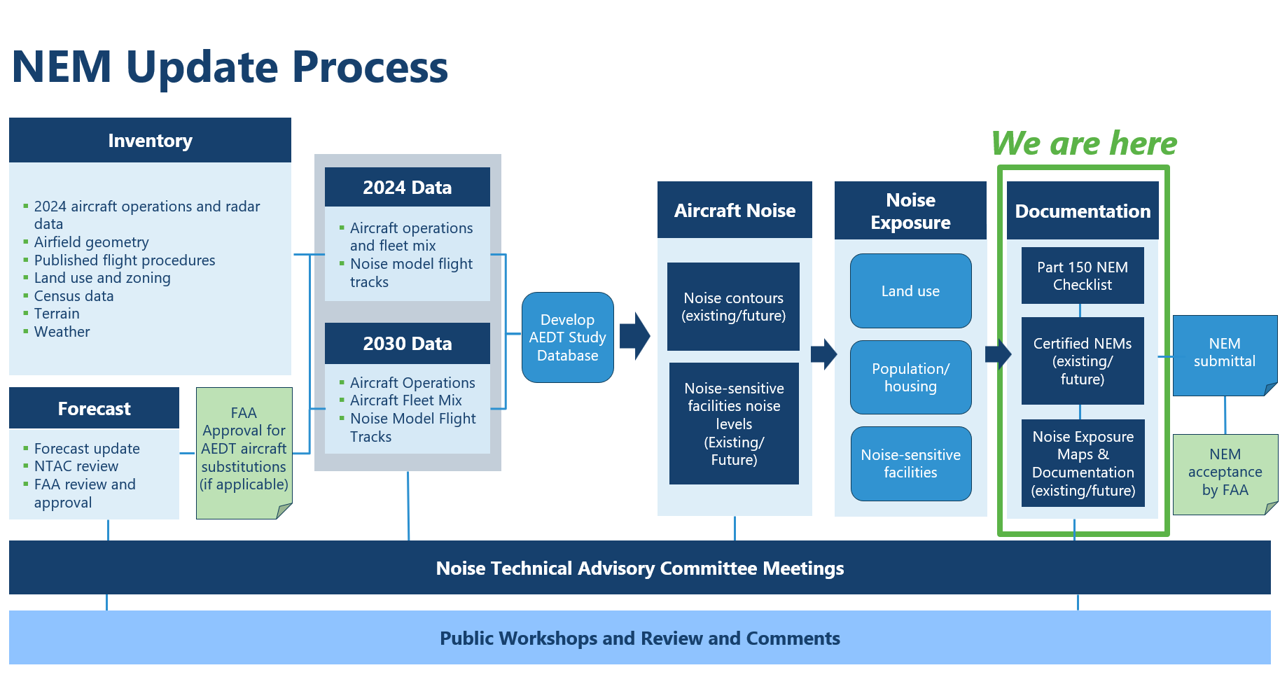
The NEM update process includes public meetings as well as the development of a Noise Technical Advisory Committee (NTAC) who will meet to discuss assumptions and inputs to the NEM Update and to gain input from community representatives and members. The materials presented at each public and NTAC meeting can be found on this webpage. A high-level overview of the NEM process is depicted below. Pease check this webpage periodically as updates regarding the NEM are posted as the project progresses.

Draft Noise Exposure Maps
BRAA is accepting public comments on the draft NEMs and accompanying report. Links to the draft documents are provided below for public review and comment.
- Draft NEM Update Report (October 2025)
- Appendix A – Background Information on Noise
- Appendix B – Aircraft Activity Forecasts
- Appendix C – Operational Data
- Appendix D – Consultation and Correspondence
- Appendix E – Public Involvement
- Appendix F – Official Noise Exposure Maps
The BRAA is accepting public comments on the draft NEMs and accompanying report through November 6, 2025. All comments must be received by 5:00 P.M. Eastern. Members of the public are encouraged to share their feedback by email or mail.
By Email:
noiseexposuremap@bocaairport.com
Boca Raton Airport Authority
Printed copies of the draft NEMs and report are also available for public review during normal business hours (9:00 AM to 5:00 PM Eastern) at the following locations:
- Boca Raton Airport Authority Administration Building
903 NW 35th Street, Boca Raton, FL - Spanish River Library
1501 Spanish River Blvd, Boca Raton, FL 33431
The BRAA also invites you to attend a public meeting on October 22, 2025, to review the draft NEMs and provide input. During the meeting, attendees will be able to:
- Review the data used to develop the draft NEMs
- Ask questions and engage with members of the BRAA and its consulting team
- Submit formal comments on the draft NEMs and report
More information about the public meeting is available on this webpage under “Public Outreach and NTAC Meetings.”
BRAA encourages interested members of the public to attend the public meetings and to review the materials presented at the NTAC meetings. Interested individuals are encouraged to submit comments specific to the NEM Update. We believe that community involvement is crucial, and we welcome your insights and feedback. If you have any questions or would like to provide a comment on the project, please contact BRAA at noiseexposuremap@bocaairport.com or (561) 391-2202. All comments must be submitted in writing and will be submitted to the FAA for their review as part of this update.
Public Outreach and NTAC Meetings
The BRAA will hold two public meetings and three NTAC meetings over the course of the NEM Update. The public will have the opportunity to participate in each meeting and provide comments. Information on each meeting will be periodically posted on this webpage. We encourage interested individuals to check this webpage periodically for updates.
Any person with a disability requiring auxiliary aids or services to participate in a meeting may call Robert Pratt, Operations Coordinator at (561) 391-2202, with requests at least five business days before the meeting. Interpretation services are also available upon advanced request. To make arrangements for such services, please contact the study team at noiseexposuremap@bocaairport.com or (561) 391-2202 no less than five business days prior to the meeting.
Noise Technical Advisory Committee Meetings
In the third and final meeting, the Boca Raton Airport Authority will present a Noise Exposure Map Update report.
One additional NTAC meeting will be held over the course of the NEM Update. The specific date and time of the meeting will be posted as is scheduled.
Public Outreach Meetings
The first public meeting was held in conjunction with a regular BRAA Board meeting and provided attendees with an overview of the 14 CFR Part 150 Study process, forecasting methodology, and preliminary data used to develop noise contours. Attendees were also able to provide comments for consideration in the development of the NEMs.More Information
Aircraft Noise
For more information on aircraft noise, including the metrics used to describe noise and how it is measured, please visit the FAA’s webpage at FAA Noise. The FAA provides detailed explanations of various noise metrics, such as the decibel (dB) and the A-weighted decibel (dBA), which accounts for the intensity and frequency of sounds as perceived by the human ear. You can also learn about specific metrics like the Sound Exposure Level (SEL) and the Day-Night Average Sound Level (DNL), which help evaluate noise exposure and its impact over time. We invite you to explore these resources to gain a deeper understanding of how aircraft noise is assessed and managed.
Current Noise Abatement at BCT
For more information on current noise abatement and mitigation measures implemented at the Airport, please visit Noise Abatement – Boca Raton Airport. BRAA staff work continuously to maintain good relations with federal and local agencies and community groups to ensure that demonstrate our commitment to being a good neighbor. This includes working with the community to address excessive aircraft noise. As described, the BRAA has introduced several noise abatement measures to ensure the Airport remains considerate of both quality-of-life concerns and the needs of the aviation community.
Airport Noise Compatibility Planning (14 CFR Part 150)
For more information on Part 150, please visit FAA’s webpage at Airport Noise Compatibility Planning (14 CFR Part 150). This webpage provides comprehensive information on airport noise compatibility planning under Part 150 and Part 161 regulations. It includes guidelines, checklists, and policies for noise mitigation, compatibility planning, and noise exposure maps.

